New research enables a robot to chart a better course
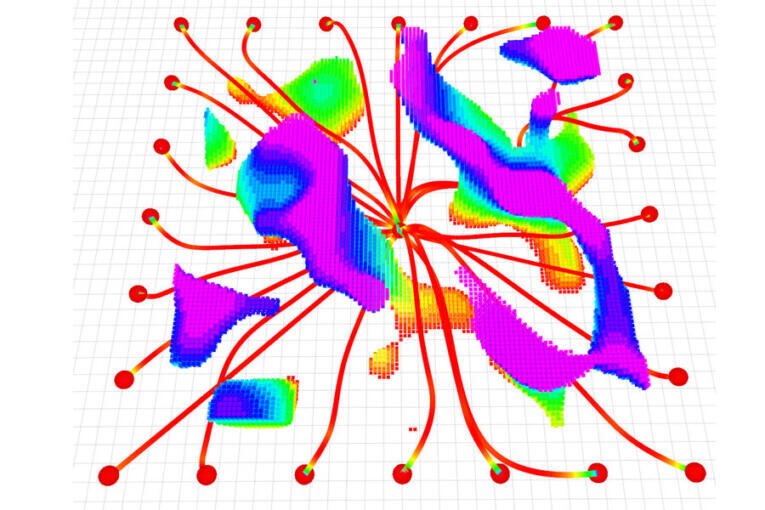
A figure shows multiple flight pathways as a UAV starts from the center and flies toward 24 goals (dots around perimeter). The flight pathways are mainly red and end in cool colors, showing reduced speed.
The rainbow clouds represent obstacles, with cooler colors representing taller obstacles. By Adam Zewe In the aftermath of a devastating earthquake, unpiloted aerial vehicles (UAVs) could fly through a collapsed building to map the scene, giving rescuers information they need to quickly reach survivors. But this remains an extremely challenging problem for an autonomous robot, which would need to swiftly adjust its trajectory to avoid sudden obstacles while staying on course. Researchers from MIT and the University of Pennsylvania developed a new trajectory-planning system that tackles both challenges at once. Their technique enables a UAV to react to obstacles in milliseconds while staying on a smooth flight path that minimizes travel time. Their system uses a new mathematical formulation that ensures the robot travels safely to its destination along a feasible path, and that is less computationally intensive than other techniques. In this way, it generates smoother trajectories faster than state-of-the-art methods. The trajectory planner is also efficient enough for real-time flight using only the robot’s onboard computer and sensors. Named MIGHTY, the open-source system does not require proprietary software packages that can cost hundreds of thousands of dollars. It could be more readily deployed in a wider variety of real-world settings. In addition to search-and-rescue, MIGHTY could be utilized in applications like last-mile delivery in urban spaces, where UAVs need to avoid buildings, wires, and people, or in industrial inspection of complex structures, such as wind turbines. “MIGHTY achieves comparable or better performance using only open-source tools, which means any researcher, student, or company — anywhere in the world — can use it freely. By removing this cost barrier, MIGHTY helps democratize high-performance trajectory planning and opens the door for a much broader community to build on this work,” says Kota Kondo, an aeronautics and astronautics graduate student and lead author of a paper on this trajectory planner. Kondo is joined on the paper by Yuwei Wu, a graduate student at the University of Pennsylvania; Vijay Kumar, a professor at UPenn; and senior author Jonathan P. How, a Ford professor of aeronautics and astronautics and a principal investigator in the Laboratory for Information and Decision Systems (LIDS) and the Aerospace Controls Laboratory (ACL) at MIT. The research appears in IEEE Robotics and Automation Letters. Overcoming trade-offs When Kondo was a child, the Fukushima Daiichi nuclear accident occurred following the Great East Japan Earthquake. With school cancelled, Kondo was stuck at home and watched the news every day as workers explored and secured the reactor site.