The OlmoEarth Platform: Geospatial inference at planetary scale
Hugging Face why satellite inference is challenging The right hardware for the right task One request, hundreds of workers, and thousands of processes Finding and fetching the right pixels Handling failure at scale Where we're headed 🌍 Learn more about OlmoEarth Platform: https://allenai.org/olmoearth The OlmoEarth models are our family of Earth observation foundation models, pretrained on roughly 10 terabytes of multimodal satellite data. Governments, NGOs, and other mission-driven organizations are already adapting OlmoEarth for applications including deforestation monitoring, food security, and wildfire risk.
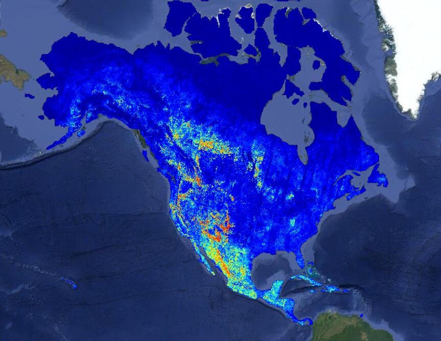
At Ai2, we know how to train and release powerful open models, and for organizations with strong engineering teams, an open model is all they need to run with. But most organizations in the environmental space – the ones best placed to apply these models – don’t have the infrastructure or engineering teams that can manage the full lifecycle: labeling data, fine-tuning models, and running large-scale inference. We’ve spent more than a decade operating platforms like Skylight and EarthRanger, software that users around the world rely on every day, so it has to work every day. That experience taught us what delivering impact takes: running models cost-effectively at the right time and place, monitoring performance, turning raw outputs into actionable insights, and verifying those outputs drive the outcomes partners want. That’s why we built the OlmoEarth Platform: infrastructure for taking geospatial models from fine-tuning and evaluation to large-scale inference. Inference at this scale presents its own set of challenges. Satellite imagery must be found and accessed across multiple providers, aligned across projections and resolutions, and processed efficiently. Results then have to be stitched into geographically consistent maps while the infrastructure recovers from the routine failures of distributed computing. Today, the platform can run inference across continent-scale areas in roughly a day, processing dozens of terabytes of imagery at a cost of fractions of a penny per square kilometer. Developing it meant confronting a series of engineering challenges that others working on large-scale geospatial systems are likely to encounter as well. This post walks through those challenges and the solutions we arrived at. A recent wildfire risk map generated on the OlmoEarth Platform, with statistics. Most ML models take in a few megabytes of data and produce a result in under a second—think LLMs processing a paragraph of text or computer vision models analyzing a photo from a smartphone. Earth observation inference operates at a very different scale—a single job fine-tuning a foundation model for maximum performance can move terabytes of data and run for hours. The inputs may span multiple spectral bands, sensor types, and time steps across a large geographic area.